
Storm Details and Current Status
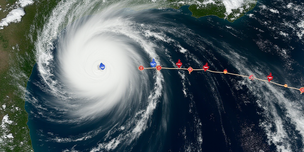
On the early morning of Sunday, June 8, Tropical Storm Barbara formed in the Pacific Ocean, south of Guerrero’s coast. According to Mexico’s National Weather Service (SMN), at 03:00 hours, the system was located 290 kilometers south-southwest of Zihuatanejo, Guerrero. Barbara has maximum sustained winds of 75 km/h, gusts up to 95 km/h, and is moving west-northwest at a speed of 19 km/h.
The storm’s circulation and moisture are causing poor weather conditions in several Pacific coastal Mexican states.
Heavy Rainfall and Strong Winds Forecasted
Heavy rainfall (50 to 75 mm) is expected in Guerrero and Michoacán, while moderate rainfall (25 to 50 mm) is forecasted for Colima and Jalisco. Additionally, sustained winds of 30 to 50 km/h are expected, with gusts reaching up to 80 km/h. High waves (4 to 5 meters) are anticipated along the coasts of Colima and Michoacán, and 3 to 4 meters along the coasts of Jalisco and Guerrero.
Intense rainfall could lead to landslides, increased river and stream levels, and potential flooding in low-lying areas. Authorities urge the public to stay informed and follow recommendations from civil protection.
Barbara Expected to Intensify into Hurricane by Monday
The SMN predicts that Barbara will intensify into a hurricane by Monday, off the coasts of Colima and Michoacán.
Recommendations from Authorities
- Exercise extreme caution due to strong winds and pay special attention to structures made of lightweight materials, as well as potential impacts on billboards and power lines.
- Exercise extreme caution when traveling on roads and rural paths, mountain passes, and urban areas; consider alternative routes if necessary.
- If traveling on the street, exercise extreme caution as wind gusts can pick up and turn objects into projectiles; seek shelter in solid homes and buildings.
- In your home, keep some windows open (preferably on the leeward side), and avoid staying in rooms facing the wind direction with large glass windows. Stay away from windows and, if necessary, protect yourself under solid and heavy furniture or interior stairs.
About Tropical Storm Barbara and its Potential Impact
Tropical Storm Barbara is a weather system forming in the Pacific Ocean, south of Guerrero’s coast. Named after the alphabetical list used for tropical storms, Barbara is currently a tropical storm with maximum sustained winds of 75 km/h and gusts up to 95 km/h. It is moving west-northwest at a speed of 19 km/h.
As Barbara approaches the coasts of Colima and Michoacán, the SMN predicts its intensification into a hurricane by Monday. This development could bring heavy rainfall, strong winds, and high waves to the affected regions.
Key Questions and Answers
- What is Tropical Storm Barbara? Tropical Storm Barbara is a weather system forming in the Pacific Ocean, south of Guerrero’s coast. It is currently classified as a tropical storm with maximum sustained winds of 75 km/h and gusts up to 95 km/h.
- When is Barbara expected to intensify into a hurricane? The SMN predicts that Tropical Storm Barbara will intensify into a hurricane by Monday, off the coasts of Colima and Michoacán.
- What weather conditions can we expect due to Barbara? Heavy rainfall, strong winds, and high waves are expected in Guerrero, Michoacán, Colima, and Jalisco. These conditions could lead to landslides, increased river and stream levels, and potential flooding in low-lying areas.
- What precautions should people take? Authorities recommend exercising extreme caution due to strong winds, keeping an eye on lightweight structures, and considering alternative travel routes. People are advised to seek shelter in solid homes and buildings during the storm, keeping windows open on the leeward side and avoiding rooms with large glass windows facing the wind direction.


