
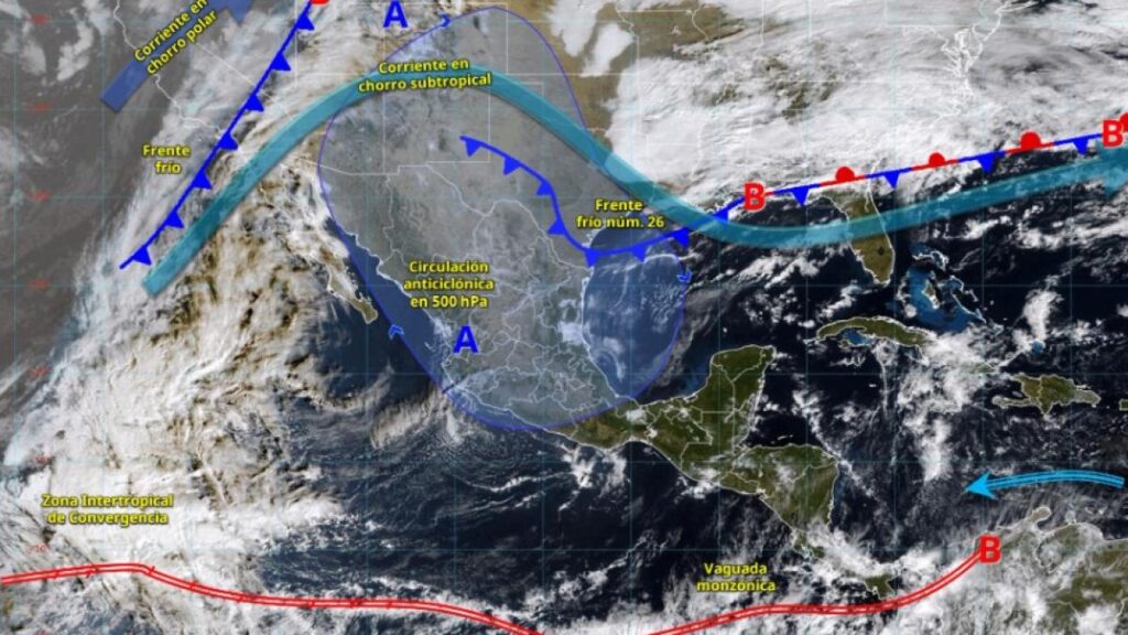
National Meteorological Service (SMN) Forecasts Cold Front 26
The National Meteorological Service (SMN) predicts that Cold Front 26 will enter northern and northeastern Mexico on Sunday, causing strong winds and a significant drop in temperature across the mentioned regions.
Simultaneous Entry of Second Cold Front
According to the SMN, a second cold front will enter simultaneously from Mexico’s northwest, combining with the subtropical jet stream. This will result in strong winds and showers in Baja California.
Key Weather Conditions
- Isolated rainfall (0.1 to 5 mm): Jalisco, Colima, and Chiapas.
- Wind: 10 to 20 km/h with gusts of 30 to 50 km/h in the Gulf of California, Baja California Sur, Coahuila, Nuevo León, Tamaulipas, San Luis Potosí, Querétaro, Hidalgo, Puebla, and the coast of Sinaloa.
- Maximum temperatures: 35 to 40 °C in Colima, Michoacán, Guerrero, and Oaxaca, as well as the coast of Jalisco.
- Maximum temperatures: 30 to 35 °C in Sinaloa, Nayarit, Tamaulipas, San Luis Potosí, Morelos, southeastern Puebla, and the Isthmus of Chiapas.
- Minimum temperatures: -10 to -5 °C with frost during Sunday morning in the mountainous regions of Chihuahua and Durango.
- Minimum temperatures: -5 to 0 °C with frost during Sunday morning in the mountainous regions of Baja California, Sonora, Coahuila, Nuevo León, Zacatecas, Guanajuato, Estado de México, Hidalgo, Tlaxcala, Puebla, and Veracruz.
- Minimum temperatures: 0 to 5 °C during Sunday morning in the mountainous regions of Aguascalientes, Jalisco, Michoacán, Querétaro, the Valley of Mexico, Morelos, and Oaxaca.
Key Questions and Answers
- What is the main weather event happening in Mexico? Cold Front 26 is entering northern and northeastern Mexico, causing strong winds and a significant temperature drop.
- What is the second cold front’s entry point and impact? The second cold front will enter from Mexico’s northwest, combining with the subtropical jet stream and causing strong winds and showers in Baja California.
- What are the expected rainfall conditions? Isolated rainfall of 0.1 to 5 mm is expected in Jalisco, Colima, and Chiapas.
- What wind conditions can be expected? Winds will range from 10 to 20 km/h with gusts of 30 to 50 km/h in the Gulf of California, Baja California Sur, and several other states.
- What are the maximum temperature forecasts? Maximum temperatures will range from 35 to 40 °C in Colima, Michoacán, Guerrero, Oaxaca, and Jalisco’s coast. Other regions will see maximum temperatures between 30 to 35 °C.
- What are the minimum temperature forecasts? Minimum temperatures will drop to -10 to -5 °C with frost in Chihuahua and Durango’s mountainous regions. Other mountainous regions will see minimum temperatures between -5 to 0 °C with frost.
- What is the general temperature range expected? The majority of Mexico will experience temperatures between 0 to 5 °C during Sunday morning in their respective mountainous regions.


